
Items
Site
The Medicine Chest
keywords is exactly
Pitt Rivers
-
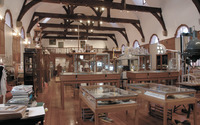
Curiosity CLXXV
Hiddingh Hall during the construction of the installation of Curiosity CLXXV. -

Hiddingh Hall
Hiddingh Hall prior to the installation of Curiosity CLXXV. -

Navigation chart, Micronesia
"Early Pacific seafarers did not have scientific instruments or conventional European-style maps to voyage to, and settle, the thousands of islands of Micronesia and Polynesia. Instead they used the movement of the sea, the direction of the wind, the position of the sun and stars, and the flight of birds. This is a navigation chart, obtained by Georg Irmer, the Governor of the Marshall Islands from Chief Nalu of Jaluit atoll in 1896. The strips of wood, bound by cane, represent the currents and winds, and the six small, white shells represent islands". -

175 chalk-board dusters
For the exhibition, 'Curiosity CLXXV', the curators took an old duster from each teaching venue and replaced it with a new one.
