
Items
Site
The Medicine Chest
keywords is exactly
map
-
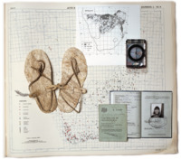
Page 175 of the Curiosity CLXXV catalogue
"The page presents a curated collection of images: a map from the Avian Demography Unit illustrating the distribution of the bataleur Terathopius ecaudatus along the political border, though the bateleur is more frequently found where there is no formal farming; a Ngwato child’s oxhide sandals collected by Isaac Schapera (a British social anthropologist who worked in South Africa and Botswana); a compass; the identification documents of Paula Ensor (previous dean and Professor of Education), who spent time in exile in Botswana; and a Certificate of Registration necessary for movement across borders, all of which are overlaid on top of a large map from the Afrikaans Atlas provided by Rajend Mesthrie of the Department of Linguistics and Southern African Languages that shows the Afrikaans language’s distribution. Contextualising all of these objects in relation to the large map cuts across disciplinary boundaries and illustrates the scope and impact of the colonial and apartheid regimes and their influence on immigration laws, language studies, ornithology and anthropology" (Liebenberg 2021: 193). -

Rice child (Stirrings)
"An object-study of a grain of rice by the artist Elaine Gan similarly shows the intermingling temporalities of humans, nonhumans and machines through an assemblage of images, text and vectors maps. Gan explores four temporalities within this research – the time of technologies, matter, memory and a calendar year – and installs the work as a long horizontal strip that cannot be viewed in full from a fixed position but encourages the viewer to walk ‘through time, occupy multiple positions’ and in so doing ‘trace new connections’ (Gan 2021). Time-travelling over two thousand years, Rice child (Stirrings) (2011) begins in the Mekong Delta, where the farming of champa rice facilitated the formation of stable settlements. It then follows a selection of rice varieties, revealing how they became technologies that accumulate socio-political formations, and weaves through the 2007/8 food crisis" (Liebenberg 2021: 28). -

Navigation chart, Micronesia
"Early Pacific seafarers did not have scientific instruments or conventional European-style maps to voyage to, and settle, the thousands of islands of Micronesia and Polynesia. Instead they used the movement of the sea, the direction of the wind, the position of the sun and stars, and the flight of birds. This is a navigation chart, obtained by Georg Irmer, the Governor of the Marshall Islands from Chief Nalu of Jaluit atoll in 1896. The strips of wood, bound by cane, represent the currents and winds, and the six small, white shells represent islands". -

The Hunting of the Snark
"The Hunting of the Snark offers a timely caution for geographical investigation. The danger, both academic and pragmatic, of enslavement to static conceptual categories, rigid classifications, and established methodological procedures is simply that they tend to rule out the possibility of experiencing that insight and understanding which can be neither discovered, formulated nor communicated by adherence to traditional investigative methdologies. This is not to advocate an un-methodical and irrational geographical philosophy, but rather to suggest that there may be conditions under which slavish adherence to a tried and tested methodology may fail to provide reliable guidance in our search for understanding. A lack of commitment to open-ended investigation could mean that, because our methods are inappropriate, our explorations will forever remain, so to speak, 'snarked' ". -

Ocean Chart
"He had bought a large map representing the sea, Without the least vestige of land: And the crew were much pleased when they found it to be A map they could all understand". -

Unconquerable Spirit: George Stow and the landscapes of the San
In 2008, the exhibition 'Unconquerable Spirit: George Stow and the landscapes of the San' opened at the Iziko Museum of South Africa. Curated by Pippa Skotnes, the exhibition featured the work of a relatively unknown figure in 19th century South African history. George William Stow was a British born, South African geologist, ethnologist, poet, historian, artist, cartographer, and writer who was responsible for a creating large collection of watercolours and drawings that documented the rock art he found in the caves and shelters of South Africa. The exhibition brought together a vast range of materials representing Stow’s life and the period in which it was produced – from his drawings and paintings; his letters, documents, and poems; to his maps, and field diaries. The display shows one map in particular which is kept as part of the National Library of South Africa collections, and was drawn by Stow during the period he was conducting geological surveys of the country surrounding the diamond fields of Kimberley, down to the junction of the Orange and Vaal rivers and beyond. It shows amongst other things, the diamondiferous deposits of the Vaal river during the late 19th century and, as part of this section of the exhibition which focused on Stow the geologist, Skotnes displayed it alongside relevant disciplinary materials she sourced from the Department of Geological Sciences, University of Cape Town. -

Geological Map of the Vaal River (from 'Stow: a geological fieldguide of UCT')
"Stow’s discovery of coal deposits in 1878, found in the beds of the Vaal River, was of interest to the diamond magnate, Sammy Marks. Marks realised the importance of Stow’s discovery and the opportunity for using coal at the Kimberley diamond fields for energy generation (Leigh, 1968:112). He believed he could transport the coal from Vereeniging to Kimberley by floating it down-river by a series of weirs to his diamond claims. This turned out to be impractical and he had to resort to using ox-wagons as a method of transport instead (Leigh 1968:17). Marks & Lewis who at that time owned a quarter of all the Kimberley diamond claims, sold most of their Kimberley claims to concentrate on the coal finds through their newly formed mining company, the Zuid-Afrikaansche en Oranje Vrystaatsche Mineralen en Mijnbouvereeniging (later to become the Vereeniging Estates Limited). In 1892, the small village of Vereeniging was formally established" (Liebenberg 2021). -

Geological Map of the Vaal River
Geological Map of the Vaal River, from Fourteen Streams to the Kareyn Poort shewing the Various Formations, and the Positions of the Diamantiferous Deposits. Sheet No 11'.
