
Items
Site
The Medicine Chest
keywords is exactly
navigation
-

Navigation chart, Micronesia
"Early Pacific seafarers did not have scientific instruments or conventional European-style maps to voyage to, and settle, the thousands of islands of Micronesia and Polynesia. Instead they used the movement of the sea, the direction of the wind, the position of the sun and stars, and the flight of birds. This is a navigation chart, obtained by Georg Irmer, the Governor of the Marshall Islands from Chief Nalu of Jaluit atoll in 1896. The strips of wood, bound by cane, represent the currents and winds, and the six small, white shells represent islands". -
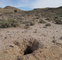
Holes
The landscape of the Karoo and the Northern Cape – the land of the |xam – is rich with holes in the ground. Below the surface of the earth burrowing animals navigate their way through the roots of grasses and shrubs, small trees and creepers. Holes are made and inhabited by scorpions and spiders, mice and shrews, suricats and mongooses. One of the most energetic of burrowers is the anteater whose holes, in places, transform the landscape. Anteaters are such active diggers and their holes so numerous that abandoned burrows are quickly occupied by bat-eared foxes, hyenas, hares, civets, bats, jackals, owls and porcupines (Skotnes 2010: 26) -
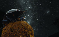
Dung beetles
Like ancient seafarers, dung beetles can navigate using the starry sky and the glow from the Milky Way. After locating a fresh pile of feces, dung beetles will often collect and roll away a large piece of spherical dung, then climb on their dung balls and dance around in circles before taking off. This dance is not one of joy, however; the insects are watching the sky to get their bearings.
