
Items
topic is exactly
Cape Town Street Plans
Item set
The William and Yvonne Jacobson Digital Africana Program at UCT
-
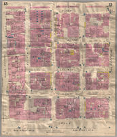
[Insurance plan of Cape Town, Cape Colony, South Africa]
This plan is numbered Sheet 13. The sheet shows details of the construction and use of buildings within the area bounded by Queen Victoria, Bloem, Bree and Wale Streets. The sheet records street names, widths and numbers; fire-protection facilities (including the location of salt and fresh water hydrants); materials, shape, height, placement and use of buildings; the location of openings, types of stored materials and areas of high-risk activites on industrial sites. -

Bird's eye view of Muizenberg
Lithographic copy of a watercolour pictorial view of Muizenberg showing houses, roads, bridges, mountain and beach with beach huts and swimmers. Below the painting is a plan showing plots in the Muizenberg (Lakeside) Estate area between the Main Road and "Muizenberg Lake". -
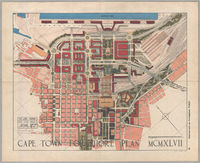
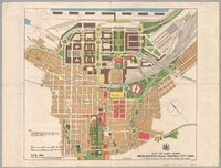
Cape Town City Foreshore plan
Map shows proposals for the Cape Town Foreshore. -
City of Cape Town :
T.P.R. ; 1653 -

City of Cape Town and environs
This street plan of Cape Town shows the central business district and the peri-urban and suburban areas of the city including the City Bowl area, the Atlantic Seaboard, the Southern Suburbs, the Northern Suburbs, the Cape Flats and the False Bay area. Included are Woodstock, Good Hope model village, Tiger Oats Township, Kensington, Windermere, Factreton, Epping plantation, Uitvlugt, Gatesville, Belgravia, Sanatorium Township, Pinelands and the Garden Cities site, Ndabeni, Hazendal, the proposed Bokmakirie Township, Goodwood, Langa, Welcome, Groote Schuur Estate, Kirstenbosch, Lotus River, Ronde Vlei, Zeekoe Vlei, Grassy Park, Strandfontein Coast Forest Reserve and Table Bay harbour. -

City of Cape Town and environs
This 1937 monochrome map shows the central business district and the peri-urban and suburban areas of Cape Town including Gardens, Oranjezicht, Vredehoek, Tamboers Kloof, Woodstock, Salt River, Brooklyn, Good Hope model village, Milnerton, Paarden Eiland, Maitland, certificate of registered title for Montagu Gardens, Sanddrift, Tiger Oats Township, Kensington, Windermere, Factreton, Epping plantation, Uitvlugt, Gatesville, Belgravia, Sanatorium Township, Pinelands and the Garden Cities site, Ndabeni, Hazendal, the proposed Bokmakirie Township, Goodwood, Langa, Welcome, Observatory, Mowbray, Rosebank, Rondebosch, Groote Schuur Estate, Kirstenbosch, Newlands, Claremont, Kenilworth, Constantia, Wynberg, Plumstead, Diep River, Heathfield, Retreat, Lotus River, Schaap Kraal, Tokai, Silvermine, Ronde Vlei, Zeekoe Vlei, Grassy Park, Strandfontein Coast Forest Reserve, Montagu's Gift, Ilfracombe Estate, Dreyersdal, Lakeside, Muizenberg, St James, Kalk Bay, Clovelly, Fish Hoek, Glencairn, Red Hill, Simonstown, Simon's Bay, Kommetjie, Sweet Water, Witsands, Noordhoek, Scarborough, Hout Bay, Chapman's Peak, Kronendal, Oude Kraal, Bakoven, Camps Bay, Clifton, Sea Point, Fresnaye, Green Point, Mouille Point and Table Bay harbour. -

City of Cape Town and environs
This 1931 shaded map of Cape Town shows the central business district and the peri-urban and suburban areas of the city including Gardens, Oranjezicht, Vredehoek, Tamboers Kloof, Woodstock, Salt River, Brooklyn, Good Hope model village, Milnerton, Paarden Eiland, Maitland, certificate of registered title for Montagu Gardens, Sanddrift, Tiger Oats Township, Kensington, Windermere, Factreton, Epping plantation, Uitvlugt, Gatesville, Belgravia, Sanatorium Township, Pinelands and the Garden Cities site, Ndabeni, Hazendal, the proposed Bokmakirie Township, Goodwood, Langa, Welcome, Observatory, Mowbray, Rosebank, Rondebosch, Groote Schuur Estate, Kirstenbosch, Newlands, Claremont, Kenilworth, Constantia, Wynberg, Plumstead, Diep River, Heathfield, Retreat, Lotus River, Schaap Kraal, Tokai, Silvermine, Ronde Vlei, Zeekoe Vlei, Grassy Park, Strandfontein Coast Forest Reserve, Montagu's Gift, Ilfracombe Estate, Dreyersdal, Lakeside, Muizenberg, St James, Kalk Bay, Clovelly, Fish Hoek, Glencairn, Red Hill, Simonstown, Simon's Bay, Kommetjie, Sweet Water, Witsands, Noordhoek, Scarborough, Hout Bay, Chapman's Peak, Kronendal, Oude Kraal, Bakoven, Camps Bay, Clifton, Sea Point, Fresnaye, Green Point, Mouille Point and Table Bay harbour. -

City of Cape Town and environs
This shaded version of the 1933 Cape Town map shows the central business district and the peri-urban and suburban areas of the city including Gardens, Oranjezicht, Vredehoek, Tamboers Kloof, Woodstock, Salt River, Brooklyn, Good Hope model village, Milnerton, Paarden Eiland, Maitland, certificate of registered title for Montagu Gardens, Sanddrift, Tiger Oats Township, Kensington, Windermere, Factreton, Epping plantation, Uitvlugt, Gatesville, Belgravia, Sanatorium Township, Pinelands and the Garden Cities site, Ndabeni, Hazendal, the proposed Bokmakirie Township, Goodwood, Langa, Welcome, Observatory, Mowbray, Rosebank, Rondebosch, Groote Schuur Estate, Kirstenbosch, Newlands, Claremont, Kenilworth, Constantia, Wynberg, Plumstead, Diep River, Heathfield, Retreat, Lotus River, Schaap Kraal, Tokai, Silvermine, Ronde Vlei, Zeekoe Vlei, Grassy Park, Strandfontein Coast Forest Reserve, Montagu's Gift, Ilfracombe Estate, Dreyersdal, Lakeside, Muizenberg, St James, Kalk Bay, Clovelly, Fish Hoek, Glencairn, Red Hill, Simonstown, Simon's Bay, Kommetjie, Sweet Water, Witsands, Noordhoek, Scarborough, Hout Bay, Chapman's Peak, Kronendal, Oude Kraal, Bakoven, Camps Bay, Clifton, Sea Point, Fresnaye, Green Point, Mouille Point and Table Bay harbour. -

City of Cape Town and environs
This street plan of Cape Town shows the central business district and the peri-urban and suburban areas of the city including the City Bowl area, the Atlantic Seaboard, the Southern Suburbs, the Northern Suburbs, the Cape Flats and the False Bay area. Included are Woodstock, Good Hope model village, Tiger Oats Township, Kensington, Windermere, Factreton, Epping plantation, Uitvlugt, Gatesville, Belgravia, Sanatorium Township, Pinelands and the Garden Cities site, Ndabeni, Hazendal, the proposed Bokmakirie Township, Goodwood, Langa, Welcome, Groote Schuur Estate, Kirstenbosch, Lotus River, Ronde Vlei, Zeekoe Vlei, Grassy Park, Strandfontein Coast Forest Reserve and Table Bay harbour. -

City of Cape Town and environs
Text in English and Afrikaans. -

City of Cape Town and environs
Text in English and Afrikaans. -

City of Cape Town and environs
Text in English and Afrikaans. -

Insurance plan of Cape Town
Each sheet shows the plan and vertical cross-section of buildings on the blocks bounded by: Sheet 1, Wale, St George's, Waterkant and Adderley streets; Sheet 2, Wale, Burg, Waterkant and St George's streets; Sheet 3, Wale, Long, Waterkant and Burg streets; Sheet 4, Wale, Loop, Waterkant and Long streets; Sheet 5, Wale, Bree, Waterkant and Loop streets; Sheet 6, Wale, Buitengracht, Waterkant and Bree streets; Sheet 7, Boom, Plein, Darling and Zieke streets; Sheet 8, Stal, Grave, Darling and Plein streets; Sheet 9, Garden of new Houses of Parliament, Adderley Street, Standard Bank buildings and Grave Street.
